You have reached an archive page. Blogger.com has ended support for FTP based blogs and New York's Sixth is migrating to WordPress. These pages are only maintained as an archive. For updated content, visit New York's Sixth.com


Food & Drink Shopping Retail Services Government Real Estate Architecture Art

Hamilton Park Neighborhood & Historic District

The centerpiece of the Hamilton Park neighborhood is the namesake Victorian era park situated between Eighth and Ninth Streets and surrounded by a historic preservation district. The park is lined with both brownstones in addition to more oddly designed nineteenth century buildings. Contrasting the streets around Van Vorst Park which maintain a certain unifying similarity between each brownstone, the buildings around Hamilton have greater variety and unique flare.

The Hamilton Park neighborhood is situated roughly equidistant from the Grove Street and Pavonia PATH stations, about a ten minute walk from the center of the park. The north side of the neighborhood is bound by the twelfth street embankment which abates noise from the Holland Tunnel entrance.

The southern border of the neighborhood is the Sixth Street embankment, which serves also as the northern border to the Harsimus Cove neighborhood. In essence, traveling south along Jersey Avenue from Hamilton park is a continuous stretch of historic preservation districts up to the edge of the city where Liberty Harbor is currently under construction.

The eastern border of the neighborhood is generally considered the Newport Mall parking garages which further segregate the new waterfront from the historic neighborhoods. The Newport mall extends from Sixth Street to the Eleventh Street overpass which feeds traffic from the Turnpike directly into the mall. The presence of the mall has also amputated the Newport high-rises from the neighborhoods around Hamilton Park.

Currently, there are plans to renovate Hamilton park, a project not undertaken in more than thirty years. The Hamilton Park Association has spearhead these efforts and are organizing final proposals. Improvements to the park will include new Victorian style lampposts, benches, new walkways, a dog run, updated playgrounds, landscaping, a fountain, and restoration of the tennis and basketball courts.

In addition, for many years St. Francis Hospital bordered the park to the east along McWilliams Place. However, the old hospital buildings-- a conglomerate of structures from a myriad of time periods-- is currently being remodeled, removed, resurfaced, and renovated into apartments and retail shops. The main task of the renovation is to remove the facades from buildings built in the 1960's and 1970's and restore a look more suited to the historic neighborhood. In addition, the developer is restoring Pavonia Avenue as well as an older building on the site from the 1920's.

Labels: ,

Harsimus Cove Neighborhood & Historic District

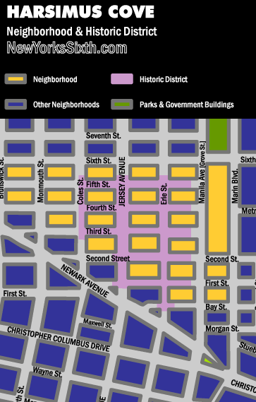
Harsimus Cove is a small neighborhood between Newark Avenue and Hamilton Park as well as a historic preservation district. Harsimus Cove is also an official light rail station between the Harborside Financial Center and the Exchange Place stops, however the station is several blocks east of the historic district. The neighborhood consists primarily of brownstones though outside of the historic district on both the eastern and western sides of the neighborhood, less elegant post-war housing has been built.

The neighborhood is in close proximity to the Grove Street PATH station as well as the Metro Plaza grocery store. Additionally, the Powerhouse Arts District abuts against the neighborhood.

The northern boundary of the neighborhood is the Sixth Street Embankment, formerly an elevated railroad track that connected the waterfront with mainland New Jersey. The embankment recently passed into the hands of private developers but local residents are advocating the construction of either a “high-line” elevated park or the removal of the embankment with a street level park.

Like many of the historic neighborhoods, Harsimus Cove has an association consisting of local residents.

Labels: ,

Newark Avenue Neighborhood & Redevelopment Zone

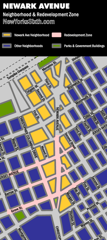
Surrounded on three sides by historically preserved neighborhoods, the Newark Avenue retail corridor was once a thriving hub of commerce. As the city declined decades ago, banks were replaced with discount stores. Today, the reversal is true. Boutiques have begun replacing pawn shops, restaurants and bars have begun to return, and new banks are returning to the once opulent buildings that once housed their 19th century counterparts.

The neighborhood of Newark Avenue does not enjoy the same de facto cohesiveness that the historic districts receive. The Harsimus Cove or Van Vorst Neighborhoods that flank Newark Avenue are very clearly defined by their historic preservation districts. The Western end of Newark Avenue though lacks any cohesive, unifying location such as the parks that clearly define Hamilton and Van Vorst neighborhoods.

In essence, the western portion of the neighborhood is bound by the elevated portion of the New Jersey Turnpike. To the south, Christopher Columbus Drive and an old elevated rail yard. To the north and east, the Harsimus Cove and Hamilton Park Historic districts create a boundary.

The Newark Avenue area has not seen the installation of large scale modern developments like the waterfront or Paulus Hook, and lacks the ornate brownstones of the historic districts. The housing stock mostly is older and in need of replacement or renovation. These needed renovations are beginning throughout the neighborhood. For now, the most affordable downtown housing units are probably here. The neighborhood is mostly Zone 1 resident parking.

Labels: ,

Van Vorst Park Neighborhood & Historic District

The Van Vorst Park area of Jersey City is both a historically preserved district as well as a de facto neighborhood. The historic district is a specialized zoning ordinance designed to protect the look of the brownstone lined streets. These zones throughout the downtown list specific lots that fall within the zoned district. Alterations to the exterior of the buildings are essentially prohibited without first getting approval from the historic commission.

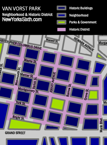
Below, a rough map of the district. The official boundaries are defined by specific lots which are not included on this map.

Van Vorst Park Historic District and Neighborhood Map

However, there is more to the Van Vorst Neighborhood than simply the historic district. The neighborhood is essentially the blocks south and west of the Grove Street Path Station, bounded by Christopher Columbus Drive to the North and Marin Blvd. to the East. The Western border is perhaps best defined as the elevated portion of the Turnpike, though some residents would declare Brunswick Street both the official western most portion of the historic district as well as the end of the neighborhood.

For many years the southern border of the neighborhood was also the edge of the city, bound by Grand Street. However, the Liberty Harbor North project will develop 27 city blocks south of the Van Vorst neighborhood. Grand Street then will be in essence the border between Van Vorst and Liberty Harbor North.

The centerpiece of the historic district is Van Vorst Park, a one square block park located on Montgomery Street and Jersey Avenue. The Victorian era park includes playgrounds, a dog run, and gardens. The summer months also bring "Jersey Fresh" sponsored Farmer's markets, and weekend rummage sellers.

City Hall and the main branch of the Jersey City Library are both located within the district. The Jersey City Museum is also located on the western edge of the neighborhood.

The area of Grove Street that runs through the neighborhood is also a busy shopping district. Cafes and restaurants line this section of Grove Street.

Planned for the neighborhood in 2007 are two new mid sized apartment complexes. The Majestic II is planned for the corner of Grove and Montgomery Streets. The project will redevelop several vacant lots and restore a number of historic brownstones. A second project known as Columbus Corner is planned for the corners of Wayne and Barrow and Barrow and Christopher Columbus Drive. That project will develop a parking lot as well as restore a Victorian era house and older apartment building.

Labels: , ,


About

New York's Sixth Directory is a review and listing of services, buildings, restaurants and shops in the de facto borough of New York: Jersey City / Hoboken.

This directory is part of the New York's Sixth network which is owned by ianmacallen.com

All original photographs and content copyright 2006 to Ian MacAllen, unless otherwise attributed.
For more information, contact ianmac47@hotmail.com

Powered by Blogger

ianmacallen.com | Annex | Archive